
Scorched Earth, Oslo Architecture Triennial, OAT 2019-2020

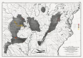
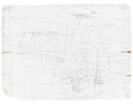
Map of the coal fields in the United States, 1870.
Dark grey indicates the locations of the anthracite basins.
Prologue
Centralia is a small borough in Columbia County in the central eastern portion of the state of Pennsylvania. As is the case with the other communities located in the region, geography played a significant role in the growth of the settlement: the rise and decline of Centralia can be attributed to visible and liminal landscapes. The topography surrounding Centralia is mountainous, with elevations as high as 600 meters. The region lies within the Appalachian Mountain range that extends south to Georgia and north into the Canadian provinces of New Brunswick and Nova Scotia. Specifically, Centralia is located in the Blue Ridge and Valley section. Within this region, settlements were established in the narrow valleys resulting in small or narrow growth patterns.
Below the visible surface lay a different set of opportunities for the region. Centralia belongs to the Anthracite Upland section, named for the abundance of easily accessible coal. Anthracite, also known as hard coal, contains a high proportion of carbon in its composition, making it more energy efficient to burn in comparison with other types of coal. Anthracite’s high energy content allows for a large number of applications from residential to industrial production: from home heating to old-style pizza ovens to high-quality water filters. Given Centralia’s spatial and topographic constraints, coal mining became the main economic activity, providing great opportunities for growth in the region.
Ironically, mining constituted the ground—both conceptually and literally—for the future degrowth of the borough.

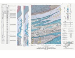
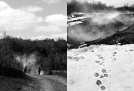
United States Geological Survey, 1971 Geologic map of the region. Centralia located in the mid-left portion of the map. Light blue indicates the Llewellyn formation, a bed rock sequence of sandstone, siltstone, shale, and anthracite coal.
ACT I : Growth
During this early period of growth, Centralia experienced the development of two complementary spatial strategies. The first was that of the borough itself, which was laid out on a cartesian grid. A small downtown with mixed- use construction developed along the east-west road. Locust Avenue, the road running north-south, connected residential areas, churches, and ceme- teries. This axis also served as the road connecting to the communities to the north and south outside the valley.
The second strategy was that of the mine. The resource rights for the land in the borough were purchased by the Locust Mountain Coal and Iron Company. As part of the extraction process, a plan was prepared and maintained to record how coal was removed from below the borough to avoid subsidence. The Centralia mines are an array of layers perforated by an irregular set of tunnels that leave untouched large portions of coal to act as a geologic structural system. Decoupled from the developments above the ground, the scale of extraction below Centralia extends far beyond the limits of the borough. While not considered as such, the process of mining was in itself an underground act of urbanization: a man-made systematic modification of nature underneath the town to maximize resource exploitation.

Centralia plan: Overlay of the city grid and the Mammoth and Buck Mountain Veins. The upper and lower sequence of blots correspond with the Buck Mountain Vein.
ACT II : Decline
The productivity of the mine started to decline by the beginning of the twen-tieth century. Changes in technology and the mobilization of young miners for World War I decreased output. Following the stock market crash in 1929, production in the area further decreased, and five mines in the region closed.
In parallel, the demand for coal slowly diminished. Oil and gas extraction processes gradually improved, making these fossil fuels more competitive and desirable than anthracite coal. The byproduct of these moments of economic decline was bootleg mining. As extraction decreased in corporate-owned mines, the members of the local population resorted to stealing coal from shuttered mines or digging up shallow veins of coal they did not own.
Unregulated individual operations of extraction increased as mines were gradually closing and created higher environmental risks. All of these factors contributed to the slow, incremental decline of Centralia, following the regional trend.
However, Centralia underwent a unique environmental catastrophe that had demographic, cultural, and ecological consequences that persist to this day.
In 1962, town officials had designated a former strip mine in the Buck Mountain vein as a landfill to comply with state environmental regulations. Prior to Memorial Day in 1962, the borough carried out a clean-up project at the landfill, which was adjacent to a cemetery. Firemen hired by the borough set the landfill on fire. Once the burn was determined to be completed, the fire was doused with water, but remained smoldering in the lower depths of the garbage. Upon closer inspection, state officials learned that the landfill pit had not been properly sealed and a portion of it was open to the mine tunnels below.
The fire spread into the mines, which extended under Centralia. Three attempts to stop the fire were made between August of 1962 and March of 1963. The first attempt proved to be counterproductive, exposing the fire to additional oxygen that fed the flames. The second attempt involved the use of a crushed rock slurry to suffocate the fire. The first two projects were abandoned when money ran out, before the fire was controlled. That same fate befell the third project.
The immediate impact on the community was one of environmental risks. The continuous combustion had the effect of turning the ground into an abnormally warm thermal mass. In 1979, a gas station owner discovered that the temperature of the gasoline in the tanks below ground was 77 degrees Celsius. In 1981, a sinkhole opened up in the backyard of one of the houses, and a boy fell in. Testing air quality in the borough became compulsory for residents after initial results showed that there were dangerous levels of carbon monoxide in some Centralia homes because of the mine fire. The situation was unacceptable from an environmental, social, and political point of view, triggering action by government officials at the state and federal levels.

ACT III : Landscape of Memory
It is unclear for how long the fire will keep burning: some accounts indicate that the mine will be on fire for fifty more years; others venture two hundred years; a few are undecided. The street grid is still intact. Garden walls and curbs remain. Street trees and shrubs planted by former property owners still grow and bloom in the spring. Theyare complemented by ruderal growth and the invasive species thriving in the area since no one is there to control the vegetation. Centralia has essentially been turned into a near ghost town. Paradoxically, the only signs of growth are related to death. Three cemeteries are still active. Former residents remain attached to the place, and the community continues to request that their bodies be buried in those cemeteries. Small rituals result in sporadic visits to inter a newly deceased resident or a return visit by family and friends of the deceased.
Other seemingly oppositional rituals occur in Centralia. A section of Route 61 was damaged beyond safety as a result of the mine fires. This section was closed in the 1990s and traffic detoured onto an existing road nearby. The abandoned part of the road has become the site for graffiti by residents of the adjacent communities. Off-roaders speed and ride through the terrain the road has become: a playground for daring motorists. A contrasting ritual is the annual cleanup day that occurs in the community.Regularly since 2014, volunteers come to the borough to remove debris and litter left from illegal dumping or careless visitors.
From burials to mine fire, the underground urbanism continues showing us the interrelatedness of the city grid to the ground underneath. The issue affecting Centralia is not unique: harvesting energy from coal-mine fires has become an emerging topic worldwide in an effort to remediate the dystopia created by these events. The earth embodies energy that capitalism is reluctant to give away. The most relevant studies focus on large-scale, cost-effective, sustainable ways of producing energy from geothermal systems. In the case of Centralia, the substantial geothermal gradient is due to the shallow presence of the fires in the coal-mine seams. Instead of economic appropriation, we are proposing a small-scale system consuming the energy below to memorialize the environmental, social, and cultural catastrophe of the borough.

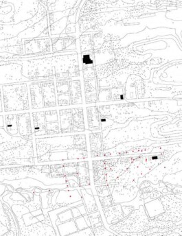
In red, location of existing boreholes. Buildings demolished since the 1980s have a grey outline. In black, standing buildings. Every cross represents a tree of the area.

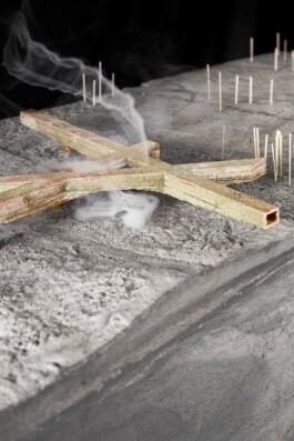
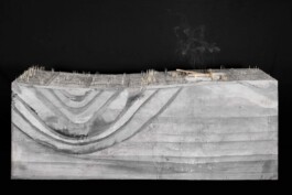
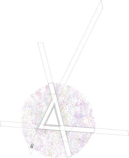
Plan 1: Filtering bars.

Plan 2: Infrastructure at ground level.

Plan 3: Vegetation composed by Tulips, Petunias, Sedum (Stonecrops), Hydrangea (Hortensia), Helianthus (Sun Flower)
Epilogue
The story of the decline of Centralia is complex. Starting with the extraction of material from the ground below the community, to the coal-seam fires that put the lives of residents in danger and the subsequent buyout and abandonment, the borough has been in decline since the first decades of the twentieth century. The crisis only accelerated from the 1960s to the 1980s. As we rapidly approach a community that will be comprised exclusively of deceased residents, we ask how we might memorialize these pasts—most notably the mine fire and its impact on the small community. Can we use architecture and infrastructure to call attention to the mine fires without creating further environmental impacts? How can we activate the landscape using plant material that is at once part of a place that is becoming increasingly wild but is still reminiscent of the yards of the former residents? Most importantly, how can we use architecture and landscape in the aid of memory and ritual?


Photographer: José Hevia
WEB DESIGN BY FRANPÉREZRUS.COM
BILDT ARCHITECTS © 2026